GIS SOLUTIONS:

MUNICIPAL OFFICE SUITE
- Tax Parcel Management System
- Permit Tracking System
- Development Tracking System
- Service Request Tracking System
- Road Asset Management System
- Water Asset Management System
- Sewer Asset Management System
- Water Well Management
- Access to Municipal DataWorks
- Mobile Solutions
- User Security Administration

OTHER SOLUTIONS
- Shortest Path Suite
- 911 Emergency Response
- Automated Vehicle Location
- Gas Infrastructure
- Electrical Infrastructure
- Wastewater Flow Demand
- Facility Management
- Municipal Drains
- Forestry

ADD-ONS
- Utility Shutoff/Outage
- EPANET INP Support Module

Guest Book


Project Websites


Municipal Office Suite

Development Tracking System

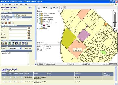
The Hunter GIS Development Tracking System (DTS) is designed to permit the tracking of the following municipal applications: building permits, status of site plans, official plan amendments, land division consents, minor variances, part lot controls and zoning amendments. The DTS simplifies the tracking process by harmonizing the diverse forms associated with development applications, employing an interface common to all applications.

Please see our BROCHURE for more information.

Development Tracking