GIS SOLUTIONS:

MUNICIPAL OFFICE SUITE
- Tax Parcel Management System
- Permit Tracking System
- Development Tracking System
- Service Request Tracking System
- Road Asset Management System
- Water Asset Management System
- Sewer Asset Management System
- Water Well Management
- Access to Municipal DataWorks
- Mobile Solutions
- User Security Administration

OTHER SOLUTIONS
- Shortest Path Suite
- 911 Emergency Response
- Automated Vehicle Location
- Gas Infrastructure
- Electrical Infrastructure
- Wastewater Flow Demand
- Facility Management
- Municipal Drains
- Forestry

ADD-ONS
- Utility Shutoff/Outage
- EPANET INP Support Module

Guest Book


Project Websites


Other Solutions

Water Well Management

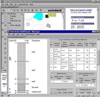
The Hunter GIS web-based Ontario Water Well Record Management Solution permits web-enabling of a wide variety of base map layers inlcuding orthophoto, elevation mass points, topographic contours, parcel mapping and many other resource and land use planning layers with linked databases.

Please see our BROCHURE for additional information.

Water Well Mgt